When we weren't exploring the area, I spent some time on my iPad browsing through Etsy and Ebay, looking through old photographs, postcards, and other random ephemera. I came upon some old maps, which isn't unusual, but a light bulb when off and I started getting this vision in my head of something I wanted to create in my house. Since we moved into this house last year, I've been trying to think of a way to create some sort of 'genealogy wall.' I had originally wanted to create a traditional 'family tree,' mixing old family photos with newer ones of my family. However, I don't have an equal amount of photos from each branch of our family, and I could just never picture how I wanted it to look.
Back to this 'vision.' I want to use maps to depict our family's journey. This idea seems natural to me; I've always loved looking at maps, I was a geography minor in college, and I used to make a living in a profession dependent on maps. I'm now currently in the process of buying older maps of the places where my and my husband's ancestors lived, worked, and traveled through. At first, I thought it would be neat if I could get a map that itself was contemporary with WHEN our ancestors were living in a particular place. This works with our more recent ancestors, but, of course, it can get very pricey when you are looking for an 18th century map of northwestern France. So, I decided to look for maps that were a little bit older, affordable, and aesthetically pleasing to the eye. (I told my husband this is coming out of our decorating budget :-) I'm searching for maps of all scales: nations, regions, counties, even individual cities that I know our ancestors had connections with. I'm going to write (or stencil) on the wall: Our Family's Journey. I've located and contacted a framing store in town that knows how to properly preserve and frame archival prints. Instead of nailing the framed maps to the wall, I'm going to use floating shelves, so that I can rearrange the display easily and even add to it without having the hassle of making more screw and nail holes.
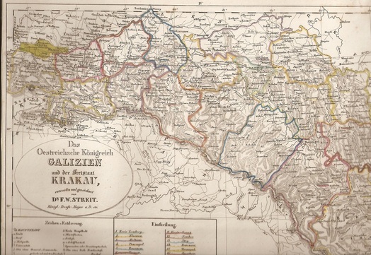
So far, I've purchased a map of northeastern France and one of an individual department where my husband's ancestors lived before coming to America. I also found a map from a late 1890s atlas depicting all the steamship line routes from Europe to the Americas. In my display, I think I also may include maps of the individual cities our ancestors embarked and disembarked from: Bremen, Naples, Antwerp, New York, New Orleans, and Baltimore. Of the maps I've purchased so far, this one is my favorite - it's an 1837 map of Galicia, where my Polish great-grandparents came from. I spent a little more money on this one, but I learned it's really hard to find a map of Galicia depicted by itself. (It's bigger than my scanner, so this is just a portion of it; and it looks a little distorted because it's in a plastic sleeve.)
